Missoula County proposes forest thinning, development guidelines in new wildfire protection plan
Prodded by last summer’s wildfires, Missoula County is revising its Community Wildfire Protection Plan, a document that identifies wildfire risks across 2,600 square miles and the actions needed to reduce or eliminate those risks.
Open for public comment through April 12, the plan will be explained during a public open house on March 22. The full document is also available online at this link.
The goal is to create a “fire-adapted” community, not to eliminate wildfires, said Adriane Beck, director of the county’s Office of Emergency Management.
The plan explains: “Eliminating wildfire from Missoula County is not possible or desirable. However, by understanding the fire environment, reducing the number of unwanted human ignitions, using prescribed fire as a tool when appropriate, and taking other measures to reduce wildfire spread and intensity around developed areas, it is possible to eliminate or reduce the loss of life and property from the wildfires that will burn in Missoula County.”
The recommended actions include everything from forest thinning and prescribed burning near subdivisions and cities to new development guidelines that discourage building in high-risk areas.
Missoula County has had a Community Wildfire Protection Plan since 2005.
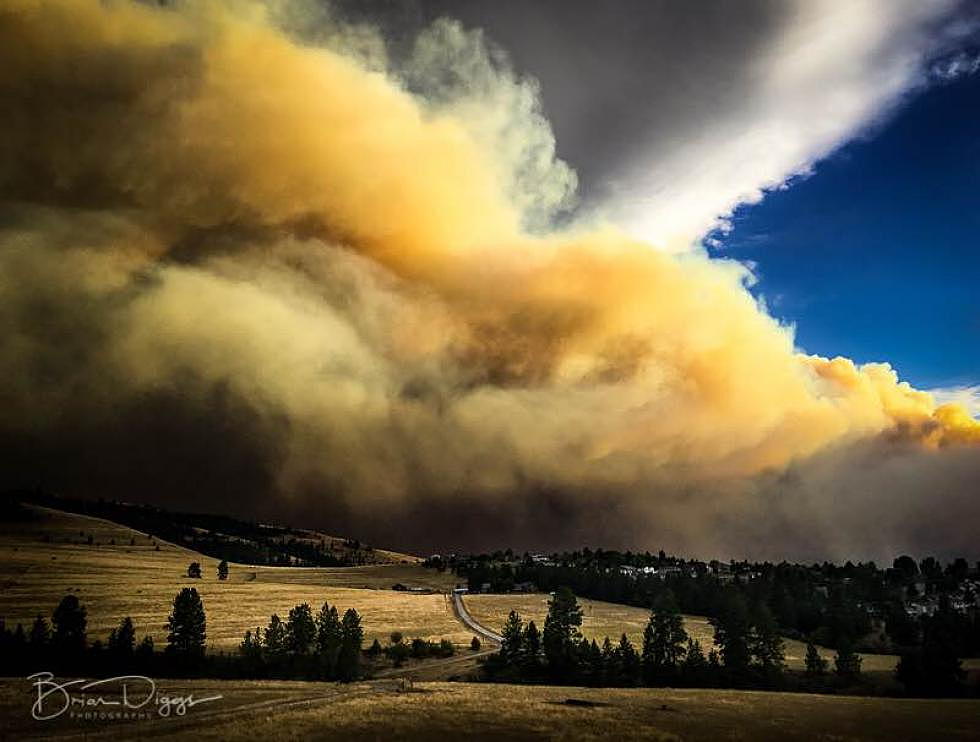
But last year’s historic fire season begged for a different, more aggressive approach – delineated in a revised protection plan. More than 230,000 acres burned in Missoula County last summer, almost four times more acres than during the next largest year (2003).
Again, the plan explains the rationale: “This plan will guide Missoula’s efforts to implement a cohesive strategy to improve our ability to respond to wildfires, create fire-resilient landscapes and promote fire-adapted communities across the county.”
Much of the document is devoted to laying out the case for more aggressive forest management, with lengthy sections explaining the local weather, historic fire regimes and behavior, future projections of fire frequency and intensity, vegetation, growth and development projections, and areas considered to be in the wildland-urban interface.
It also provides a revised definition of the WUI: “Any area where the combination of human development and vegetation have a potential to result in negative impacts from wildfire on the community.”
Beck, at the Office of Emergency Management, said the U.S. Forest Service provided Missoula County with the nation’s most sophisticated fire-modeling maps, showing the likelihood of wildfires on each of the county’s 1.7 million acres.
One of the resulting maps shows the city of Missoula virtually surrounded by middle- to upper-elevation forests with a “very high” annual burn probability.
The problem, while certainly complex, is also straightforward:
“Despite being Montana’s second-most populous county,” the protection plan says, “the vast majority of land area in Missoula County remains dominated by native vegetation. Conifer forests cover roughly 80 percent of the county, followed by 10 percent in aspen/alder/cottonwood woodlands (mostly riparian), and 6 percent dominated by grasses and shrubs.”
Combine that with the region’s arid climate, propensity for summer lightning storms, a buildup of forest fuels created by more than a century of aggressive wildland firefighting and the continued influx of new residents into rural forested areas, and you’ve got cause for concern – and action, county officials contend.
Thus the protection plan’s multi-faceted approach to reducing Missoula County’s increasing risk of wildfires, including calls to:
- Update the county growth policy’s land use map and local area plans, using wildfire-risk data to steer growth away from more hazardous areas.
- Implement land use map updates using zoning to guide growth to more appropriate areas and away from more hazardous areas.
- Utilize land conservation tools such as the open space bond to buffer developed areas from wildfire.
- Adopt development regulations that require best possible hazard mitigation to protect communities, neighborhoods, fire professionals, and properties/structures in the event of a wildfire. Propose updated development regulations that incorporate best practices, including changes to building codes, zoning, and subdivision regulations.
- Review and identify priority landscapes and options for forest thinning. Appropriate treatments (e.g. commercial thinning, hand thinning, prescribed fire) should also be determined and undertaken.
- Prescribed fire use should be advanced in areas where it is determined to be the appropriate treatment for achieving ecological restoration or hazard reduction goals and objectives.
- Implement post-fire recovery activities. The post-fire recovery activities resulting from the 2017 wildfire season are currently underway and should take priority. As a result of these activities, there may be opportunities to leverage long-term post-fire planning that can support future wildfire and prescribed fire activity.
- Engage with industry professionals on mitigation programs, activities, and opportunities to improve public education and outreach across neighborhoods and communities.
- Promote having neighborhoods and communities develop mitigation activities and evacuation plans through programs such as Firewise Communities/ USA and Ready, Set, Go!
- Promote and support fire departments to increase capacity and funding. Stakeholders and all levels of government should work together in developing a coordinated approach to increasing fire department capacity and funding with respect to wildfire response.
- Establish wildland fire response agreements between the county and fire districts. The county and local fire districts should continue to work together in establishing formalized agreements that include fire protection for lands within the county that are not currently protected.
Beck said the Office of Emergency Management will hold an open house from 5:30 to 7:30 p.m. on Thursday, March 22, in Room 151 of the Courthouse Annex, located at 200 W. Broadway St.
Participants will have the chance to meet with county staff and other stakeholders, ask questions about the plan and provide feedback during the interactive open house.
The public also can provide feedback by submitting written comments to Beck by email at abeck@missoulacounty.us or by mailing them to 200 W. Broadway St., Missoula, MT 59802. Hard copies of the plan also are available by contacting Beck.
Following the public comment period, Commissioners will consider adoption of the updated plan at a public hearing on Thursday, May 24.