New land use map intended to guide future of urban Missoula County
The Missoula Area Mapping Project is nearing the final stages of creating the first draft of a Missoula County urban area land use map.
The work of Missoula County Community & Planning Services, the project involves creating a land use map to illustrate the values and needs of communities and neighborhoods across Missoula County.
The resulting display will be used to plan for growth in the coming decades.
The current mapping project covers land from Bonner west to the former Smurfit-Stone Container mill site in Frenchtown, and from the Upper Rattlesnake Valley to Miller Creek.
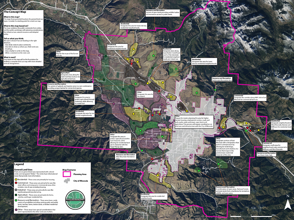
Residents have commented and offered suggestions about where they want development and which areas are important to their neighborhood, such as public lands, open spaces and residential areas. There are 64 different land use designations on the map.
Now, Community & Planning Services is requesting more input from the public about the first concept map, which shows potential locations for general land use types.
In other words, it’s a starting point for the land use map.
The concept map includes suggestions made during a first round of open houses in March, as well as planning considerations like roads, schools, sewer systems, agricultural lands and wildlife habitat.
So far, comments have emphasized the need to incorporate trails that connect individual neighborhoods to the rest of the city and suggestions for alternative forms of transportation like bus routes and bike lanes.
Compared to the most recent land use map created in mid-1970s, expanding and preserving agricultural lands is a primary focus for residents today.
“Agriculture is clearly a big issue for people. Protecting [agricultural] lands wasn’t really in the ‘74 plan so much,” county planner and mapping project manager Andrew Hagemeier said. “People want to see a much more direct approach to agriculture in our land use map today.”
During an open house this week for Bonner and West Riverside residents, participants added vibrant sticky notes and drew arrows and lines to suggest changes to previous residents’ input on the concept map.
The area consisted largely of residential, commercial, open space and agricultural land use types.
Residents suggested that areas along Zaugg Drive and First Street should be used as residential parks or community gardens.
The same area is targeted for commercial development, where incorporating a sewer system would allow businesses to thrive. Storage units currently dominate the property.
“I left a comment questioning ‘how many storage units does the community need? Or are there some other developments that would be really helpful?’ In particular, some commercial spaces, some services like a grocery store, a coffee shop, or health care,” former Bonner-Milltown Community Council member and local resident Olivia Riutta said. “Those are some things that would be helpful to me and I’ve heard from other folks of the community.”
Another local, Heather Peters, whose husband is a mobile mechanic, said that opening a hardware store in the area would be helpful.
“Sometimes he’ll get job all the way out this direction, but he has to drive all the way into town to get materials,” she said.
Constructing trails that connect the area to the city was also overwhelmingly popular.
“With the new Milltown State Park opening and the trails that are being built, there’s a ton of connectivity opportunity within the community but also the trail efforts to connect Bonner and West Riverside to East Missoula and Missoula,” Riutta said.
According to Hagemeier, the county is growing at a rate of about 2,000 people per year, and 80 percent of those new Missoula County residents will live within the boundaries of the urban land use map.
“We can deal with the rate we’re growing, but we have to have good planning in place,” Hagemeier said.
The original land use map created in the mid-1970s reflects the values of Missoula area residents of that time. The most recent update to the map came in response to neighborhood development plans around the county in 2010.
“It’s a really important tool to how we plan where development is going to occur, where we think roads are going to go, where we think schools need to expand, where sewer needs to go,” Hagemeier said. “It’s long overdue for an update.”
Additional open houses will be held after the first draft of the land use map is finished at the end of the summer.
So far one message is clear:
“They want to see this land use map really bring out the things that make Missoula great,” Hagemeier said.
Residents can still comment on the concept map through the beginning of July via the project’s interactive map on this website.